Sunday, 13 September 2009
Chao Phraya River
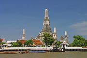
Thailand's Main. It flows south through the country's fertile central plain for more than 225 miles (365 km) to the Gulf of Thailand. The capital of Thailand, past and present (Bangkok), were placed on the bank or those of its tributaries and tributaries, like many other cities.
The Chao Phraya River, is a useful way to reflect the nation's traditional exports of teak and rice south of Bangkok, commodities, but leaner now induced overland by truck or rail. For centuries, the Thais have made use of the Chao Phraya River, and in certain channel (Khlong) system, drainage, recreation and fishing, as well as a source of water.
The sources of the River Ping, Wang, Yom and Nan rivers originate in the mountains of northern Thailand. In Nakhon Sawan, begins 140 km north of Bangkok, the Main and the confluence of the Ping-Nan. Its tortuous course flows past Chai Nat (site of a dam on the government and the irrigation system), Sing Buri, Ang Thong, Nonthaburi, and Bangkok to its mouth at Samut Prakan. Since its founding in Nakhon Sawan, the river falls below 80 feet (24 meters) on his journey to the sea.
The Chao Phraya system drains 61,807 square miles (160,079 km ²) and is the base for several large irrigation projects. The catchment area is low, the whole arm of the Gulf of Thailand, which is scarred by numerous tributaries. About Chai Nat, a branch of the river arms Nakhon Chai Si-west and parallel to the flow of the mother to the Gulf of Samut Sakhon, 25 miles (40 km) west of the main mouth. The main stream divides and meets several times. Chai Nat under the branches of the Noi River in the west and flows into the Chao Phraya river in Sam Khok. The Lop Buri river arms in the east and before returning to the main flow passes through the cities of Lop Buri and Ayutthaya, the latter receives a large tributary of the East Pa Sak river from the mountains in the northeast of Phetchabun.
Tides run along the meandering Chao Phraya to Ayutthaya. The delta plain around Bangkok is rarely more than 7 feet (2 meters) above sea level, floods and landslides collects annually rich rice fields. In the delta of the Chao Phraya River, the Mae Klong in the West, and Bang Pakong in the East are connected by a network of canals.
The course of 25 miles below Bangkok is lined with docks and port facilities. The mouth of the deep water channel requires frequent dredging and can not accommodate large ships of 10,000 tons.
Special Thank : Picture By :
www.britannica.com en.wikipedia.org 3
Video By:
www.youtube.com
Subscribe to:
Post Comments (Atom)


0 comments:
Post a Comment